Home » GeoViz brings proposals to life

GeoViz brings proposals to life

Victoria’s Manningham City Council has developed a geographical visualisation program, providing 3D models and images that greatly assist in the assessment of planning applications and design of major projects. Council took out the Innovative Management Initiative category for the program at the 2006 LG Pro awards in February.

Manningham’s GIS/GPS Officer, Michael Johnstone, said GeoViz allows Council to graphically represent proposed developments and set them in the existing built environment.

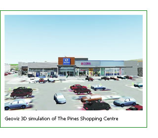
“A new community centre and restaurants are proposed for a site near one of the city’s shopping centres,” he said. “GeoViz is being used to demonstrate the relationships between the proposed buildings and the existing open space, buildings and car parks in and around the shopping centre. Interested parties, including Councillors, Council officers, architects and designers can view each proposal from a variety of angles, thereby visualising how the proposal might appear on the overall site. The program has also assisted with the community consultation process as people can get a good idea of what a proposal will mean to local amenities.”

GeoViz provides a graphical representation of any potential overshadowing and line of sight impacts, greatly assisting the selection of designs most appropriate to a particular site.

“To construct the 3D model, firstly an accurate Digital Elevation Model (DEM) of the designated area must be built using recent aerial photography and airborne laser scanning,” Michael Johnstone said. “Realistic buildings and other man made structures are then added.”

Once familiar with the software, it takes approximately two weeks to produce a simple 3D visualisation of a 100 metre square site.

Michael Johnstone said that online 3D model websites provide 3D cars, plants, trees, street furniture and people free of charge. However most sites were of little value to Manningham as they are developed for American, Asian or European requirements and conditions.

“To address this, Manningham developed its own 3D library of local cars, trees, plants, and street furniture,” he said. “These features add significant realism to the site and will be used in future Manningham GeoViz models.”

Council’s GIS/GPS team are currently working with Strategic Planners to develop 3D geographical visualisations for specific planning applications for the Victorian Civil and Administrative Tribunal (VCAT). This includes development of fly through models that are recorded on video and shown at VCAT hearings.

For further information, contact Michael Johnstone on (03) 9840 9333.

Digital Editions


  • Lismore four years on

    Lismore four years on

    Four years on: How Lismore is building back and setting a national benchmark. When the 2022 flood inundated Lismore, it was not simply another extreme…

More News

  • New-look reserve reopens

    New-look reserve reopens

    Toongabbie’s Sue Savage Reserve has reopened after a $4 million upgrade featuring a new skate park, BMX pump track, fitness equipment, an amenity building, park furniture, drainage upgrade, landscaping and…

  • Temora address housing shortage in tiny hamlet

    Temora address housing shortage in tiny hamlet

    Proposed Ariah Park Village Subdivision to Address Housing Shortage – Lots from $90-000 to $110,000 in the small picturesque hamlet. Temora Shire Council is investigating the delivery of a proposed…

  • Douglas Shire seeks renewal

    Douglas Shire seeks renewal

    Creative store opens in Mossman through empty spaces program. A new store and community art space has opened in Mossman thanks to a program designed to breathe new life into…

  • New youth and community centre for McLeay

    New youth and community centre for McLeay

    A new Youth and Community Centre planned for Macleay Island will service the needs of the growing community and will also be designed so it can support community recovery following…

  • Grants close soon

    Grants close soon

    Queensland councils have until 31 March to apply for Round two of the State Government’s Secure Communities Partnership Program, which offers up to $400,000 per project for CCTV, lighting and…

  • Sod turned on major upgrade at Paul Fitzsimons Oval

    Sod turned on major upgrade at Paul Fitzsimons Oval

    Work has officially begun on the redevelopment of Paul Fitzsimons Oval with Alice Springs Town Council and the Australian Government turning the first sod this morning. Mayor Asta Hill and…

  • Lockyer send flood expert north

    Lockyer send flood expert north

    Lockyer Valley Regional Council has answered the call for assistance from a community impacted by Ex-Tropical Cyclone Koji, with a staff member from Council’s Disaster Management Unit deployed to support…

  • From books to bots

    From books to bots

    Tenterfield Library is proving that technology is more than just tools and devices. From coding and robotics to tech support, the Library has become a place where curiosity, connection and…

  • Major repairs for levee

    Major repairs for levee

    Goondiwindi Regional Council has endorsed its largest-ever capital works project to repair and reinforce critical sections of the Goondiwindi levee, following significant erosion after recent floods. At this week’s Ordinary…

  • Stretching for a good cause

    Stretching for a good cause

    Ballarat residents stretched, smiled and snuggled their way through a unique Kitten Yoga event that combined relaxation with a heartwarming cause – helping kittens find their forever homes. Hosted by…