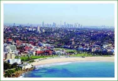
Randwick City, in the eastern suburbs of Sydney, is bounded by Centennial Park in the north, the Pacific Ocean to the east and Botany Bay in the south. The western boundary is defined by a major freeway to Sydney airport and the line of open space largely occupied by golf courses developed over low lying land known historically as the Lachlan Swamp and Botany Wetlands.
Randwick City’s 37.42 square kilometres covers the suburbs of Chifley, Clovelly, Coogee, Kensington, Kingsford, La Perouse, Little Bay, Malabar, Maroubra, Matraville, South Coogee, Phillip Bay and Randwick.
The City has extensive parkland including Centennial Park, Heffron Park and Botany Bay National Park which provides opportunities for recreation, relaxation and community interaction.
The large open space areas are habitat for over 500 species of indigenous plants and 250 species of native vertebrate animals, including several remnant communities of threatened flora and fauna.
One of Randwick’s great natural assets is its extensive coastline. The dramatic and varied 29.3 kilometre coast strongly influences the City’s character with its beautiful beaches, beachside architecture, open spaces and tourist destinations.
Coogee, Clovelly, Maroubra and Malabar beaches attract over eight million annual visitors and the La Perouse and Frenchman’s Bay area have great significance for Randwick’s Indigenous population as well as historical significance for the whole nation.
Running along the coastline is a significant part of the Eastern Beaches Coastal Walkway. As custodians of this precious coastline, Council is successfully managing the impact of the many people that visit our beaches so that these beautiful areas are maintained into the future.
This work has received national recognition, winning many awards in the annual Keep Australia Beautiful Clean Beach Challenge competition.
Randwick City is a culturally diverse community and at the 2006 Census had a resident population of 122,376. Although the population mix varies through the different suburbs, the population is largely reflective of both Randwick’s proximity to the Sydney CBD and the places of education.
A population growth of one per cent is lower than that in Sydney generally and is predicted to rise to 131,711 by 2021.
The history of land use development in Randwick City is quite unique.
The northern part of the area, Randwick, Coogee and Kensington, was developed in late 19th century and early 20th century and the infrastructure in these suburbs is quite old, often more than 100 years. However, the southern part of Randwick City was primarily developed as Crown subdivisions in the post war years with minimal infrastructure. Roads were unsealed and there was no sewerage.
Randwick City is largely residential with a mix of apartments and detached housing, with a significant percentage of public housing. In Botany Bay there is some industrial development and a major port facility.
The City has major regional facilities, including the Randwick Hospitals Complex, the University of New South Wales, Randwick TAFE, and many public and private schools.
Apart from its famous surfing beaches, Randwick City also hosts regionally significant recreational facilities such as Randwick Racecourse and five major golf courses.
These facilities and its location near the Sydney Central Business District, Sydney Airport and Port Botany contribute to Randwick’s relationship with broader Sydney’s economy.
Randwick Council has been proactive in meeting the challenges posed by its ageing infrastructure in the north, inadequate infrastructure in the south, dominant residential land uses, low rate base, extensively used regional facilities and lack of significant commercial/industrial areas, by embarking on a significant and successful reform process.
This reform process aims to achieve efficiency improvements, cost savings and increased economic, social and environmental sustainability.