Inspections and works orders of drainage infrastructure comprising 36,000 pits and hundreds of kilometres of pipes are now considerably easier for Frankston City Council with the implementation of a customised GIS application connected to GPS.
Developed by Council’s Senior GIS/GPS Projects Specialist, Paul Bormann, the application was first used by Frankston’s drainage department in 2006. Since then, it has been continually updated in stages to broaden its features and capabilities.
Paul Bormann said it was initially implemented to assist field workers locate and inspect drainage pits and record maintenance data, but its use has been expanded to include job prioritisation and sequencing, as well as yearly and quarterly proactive inspection cycles.
“The innovative solution now overcomes all previous operational difficulties in accessing, recording and improving data, and locating the drainage infrastructure in the field,” he said.
“The system does not just capture data, it handles the whole workflow from scheduling of inspections, to actually undertaking and completing the works as a result.
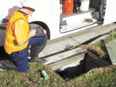
“Field workers can enter inspection and maintenance data directly into a portable tablet computer, eliminating the use of outdated and inaccurate maps, along with the associated difficulty of updating maps by hand in the field.
“Feedback from fieldworkers has been great. They find it easy to use, and the continual development of the application is mainly due to staff coming forward with ideas for upgrades and additional functionality.”
With a Stage 4 upgrade now imminent, Paul Bormann said the system will soon include more features for managing equipment and resources and will be able to handle OH&S and traffic control.
“The system will have a checklist reminding staff to ensure they have all bases covered before a particular job commences,” he said. “In the past, reporting on OH&S and traffic control was rarely done, and if it was, it was hard to find. This upgrade will allow all reports to be stored in the one location, and as they are electronic, they can easily be retrieved.”
The use of GPS in the workplace has often raised concerns of privacy, with some employees fearing policing by management. Frankston City was determined not to let this happen.
Paul Bormann consulted with and trained all field officers on the capabilities of GPS, ensuring employee confidence and trust, while demonstrating how to properly use the system.
“To replicate such a project, it is important to design and build the custom GIS application as a partnership,” he said.
“In this case, our Information Services Department continually works with the City Works Department to ensure the project meets its operational requirements.
“To avoid building a solution that did not match existing work processes, we held several workshops and demonstrations throughout the project design and implementation phases.”
It was identified early in the developmental process that the user interface would need to be very intuitive and easy to use, as the majority of the future users had limited computer experience.
This was achieved through innovative automations of GIS processes within the application, such as creation of work schedules.
Paul Bormann said the initiative has provided substantial benefits and cost savings for Council, allowing greater productivity through faster and more accurate location of drainage points.
For further information contact Paul Bormann on 1300 322 322.