South Australia’s Coorong District Council has implemented a risk management approach to address riverbank slumping caused by the ongoing drought.
Located southeast of Adelaide and with a population of approximately 6,000 people, Coorong District Council covers 8,800 square kilometres and is South Australia’s largest council in area. The Coorong region has been experiencing drought conditions and deleterious water issues associated with the River Murray and Lower Lakes due to inadequate inflows for several years.
Council’s Manager Corporate Services, Natalie Traeger, said that this lack of water has created a problem that Council had not encountered before.
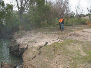
“The issue, known as slumping, can be described as riverbank levees collapsing into the river, taking with them any infrastructure that private owners, Council or other agencies had installed on these areas,” she said.
“It creates not only an environmental risk, but a liability risk, exposing Council to potential loss of assets and infrastructure, as well as public litigation.
“Several areas within neighbouring councils have slumped, taking not only infrastructure, but significant assets such as motor vehicles, sheds and trees into the river.”
When Coorong’s riverbanks began collapsing in February 2009, Council took immediate action.
“Before a river bank actually slumps, cracks appear,” Natalie Traeger said. “As such, a Local Committee Action Group was formed to assess cracks and identify all areas in which slumping was likely to occur. Council also attended several meetings with the Department of Water, Land and Biodiversity Conservation (DWLBC) to explore means of controlling the slumping and to limit loss of assets and liability exposure.
“We then used a GIS system to prepare a database of all Council owned or managed properties adjacent to the river and lower lakes.
“Having identified potential risk areas, Council then undertook a process of conducting physical inspections and creating detailed records of the findings. As part of this process, areas that were deemed unsafe were immediately secured and fenced off from the public and warning signs were installed.”
Natalie Traeger said that because this was a new and unique issue for Local Government, there was a lack of information and procedures available for Council’s reference.
Coorong took a lead role and designed a comprehensive Riverbank Assessment proforma, which was used until the Local Government Association Mutual Liability Scheme (LGAMLS) provided a similar reference tool.
As a matter of urgency, Council also developed a procedure to educate staff on how to collect information from the public for the purposes of further identifying or monitoring possible risk areas.
“Not only did this process allow Council to record the locations of where slumping was occurring, it gave customer service staff the necessary knowledge and guidelines to provide information and assistance to the public,” Natalie Traeger said.
Continuous monitoring of these sites is now conducted on a regular basis using the checklist from LGAMLS. Information is forwarded to relevant staff for review, with required actions being approved by the relevant manager and immediately carried out.
The project recently took out the LGAMLS 2009 Risk Management Award.
For further information contact Natalie Traeger on (08) 8572 3611.

