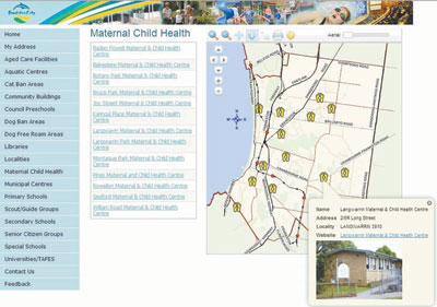
Finding what facilities and services are close to your house within Frankston City has just got easier for residents with the launch of My Address. This is an innovative mapping feature for the Frankston community located at www.frankston.vic.gov.au/My Address.
Frankston City Council worked with Digital Mapping Solutions to develop a mapping site with a fresh look and feel containing information relevant to the community.
Feedback was collected from online surveys, focus group workshops, Google analytic reports and customer service phone calls which enabled Frankston City Council to determine the top 10 customer requests.
Digital Mapping Solutions then developed a site that could be maintained by Frankston City Council GIS Team.
My Address allows members of the community to enter a street address and view a map together with a list of relevant Council facilities and community services. For example residents can enter their home address and find their:
- nearest kindergarten; pre school, primary school and secondary school
- halls, senior citizen amenities, aged care facilities
- animal free roam areas
- when waste and recycling is collected
- ward Councillors
- and much more.
My Address aims to empower the community to find their answers to information that was previously hidden within the corporate website.
My Address has reduced the time customer service staff spent taking calls from the community by providing information that can be found online quickly. On average, Frankston’s customer service team received approximately 500 calls per day, from this, half relate to waste and recycling, animals, rates and town planning issues combined.

