Geo-imagery, whether from satellites, planes or drones, has become an integral part of our online experiences in work or play. Navigation apps, looking for a hotel or a new home, we use imagery to provide the context and location. That same imagery also delivers so much more information about our environment. It provides the big picture, shows your infrastructure and assets and their condition. We can see and measure change that cannot be perceived from the ground. But really, how reliable and useful is this imagery?
There is a lot of free and easily accessible imagery out there: Google, Bing, Here, and a variety of State Globes. The detail is awesome but that is not of much use when it is three years or more out of date. It may be a case of not being able to see the forest for the trees. The level of detail needs to be appropriate to your application – the higher the resolution, the higher the acquisition and processing costs and the lower the likelihood of frequent update.
Resolution is not the only attribute of imagery that makes it useful. The quality needs to be consistent across your whole area of interest; you need access to historical imagery so you can track change and it has to be accurately located so your analysis can be mapped, reported and believed-in.
We have all dreamed what fun drones would be for acquiring all the imagery we want. Flying the drone would be fun but then the real work begins. The stark reality is that drones are good for small areas and projects, however in the end somebody has to knit all those small images into an image-base and handle the administration of its distribution and management. This is just not feasible for the hundreds, if not thousands of square kilometres you need to access to do your job.
A solution for many of these issues is One Atlas, the satellite imagery library recently released by the Intelligence business line of Airbus Defence and Space.
- always fresher than one year
- global coverage
- consistent, homogeneous, with minimal cloud cover
available 24/7 by viewer or image web service to your GIS (geographic information system) - easy sharing amongst multiple teams
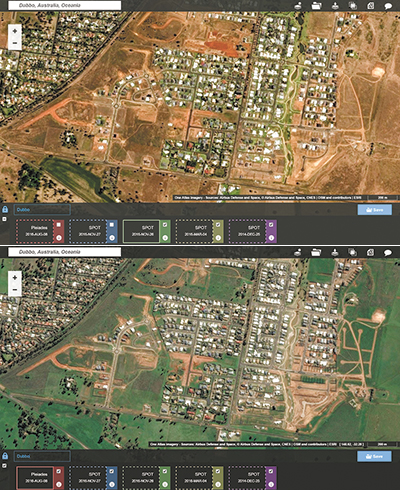
- historical imagery over your project for change analysis
- no procurement, processing, information technology administration or storage issues; costs are drastically reduced
- secure and private.
One Atlas supplies a constantly updated image base down to 50cm detail that is always less than 12 months old. Our satellites have dedicated tasking to ensure, ongoing, new, cloud free, global imagery acquisitions. The Airbus optical satellite constellation allows for a global image base at 1.5m resolution and down to 50cm over major cities and urban areas. More than enough to count the trees and see where cars are parked.
The raw data is inspected by our imagery experts to ensure that seasonal effects, haze and clouds, are kept to an absolute minimum through a process of careful manual selection – only the very best sections from each capture are retained. The imagery has been orthorectified using reference data which is accurate to +/-5m across Australia so you can have the confidence of map accurate positioning. On a global basis, each week our team screens, validates and pushes to the cloud 2,000,000 sq. km of “clean” imagery. That’s twice the land area of New South Wales.
You can securely access the data using our Viewer, link to our cloud server and stream the imagery into apps such as Google Earth or ArcGIS Earth or use Open Geospatial Consortium (OGC) compliant services to analyse the data in your desktop mapping or GIS software. Even better, by using the composer in our viewer you can create custom views and layering so you can stream images from multiple dates to help detect and monitor change. Airbus takes care of everything: updating, selecting, processing and hosting – all to make it easier, cheaper and faster for you.
Airbus Defence and Space and its predecessors have been operating the SPOT series of high resolution earth observation satellites for more than 30 years. SPOT 1 was the first commercial high resolution optical earth observation satellite when it was launched in 1986. SPOT 6 and SPOT 7 currently provide One Atlas with a global 1.5m resolution. Over cities and major towns this imagery is supplemented by 50cm detail provided by our two Pléiades satellites.
For more information or a webex demonstration:
sales @airbus-geo.com.au
*Copy supplied by Airbus DS Geo Australia