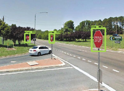
Councils can now monitor street signs for repair or replacement by tapping into Google Street View images, thanks to a program developed by geospatial scientists at Victoria’s RMIT University.
The fully automated system is trained using AI-powered object detection to identify street signs in the freely available images.
Study lead author and RMIT University Geospatial Science Honours student, Andrew Campbell, said the proof-of-concept model was trained to see ‘stop’ and ‘give way’ signs, but could be trained to identify many other inputs and was easily scalable for use by local governments and traffic authorities.
“Councils have requirements to monitor this infrastructure but currently no cheap or efficient way to do so.
“By using free and open source tools, we’ve now developed a fully automated system for doing that job, and doing it more accurately.”
Campbell credited the project’s initial concept to his industry mentor at Alpine Shire Council and RMIT Geospatial Science alumnus, Barrett Higman.
RMIT geospatial scientist and project co-lead, Dr Chayn Sun, said the fact that some councils were already attaching cameras onto rubbish trucks to gather street footage showed how valuable visual data were becoming, given what technology could now do with it.
“This imagery is critical for local governments in monitoring and managing assets and with the huge amount of geospatial applications flourishing, this information will only become more valuable.
“Ours is one of several early applications for this to meet a specific industry need but a whole lot more will emerge in coming years.”
Sun said footage from other sources, like that from rubbish truck cameras or any other geo-referenced imagery of the road network collected by councils, could also be fed into the system.
“Where footage is already being gathered, our research can provide councils with an economical tool to drive insights and data from this existing resource.”
The project was co-led by Sun and fellow RMIT geospatial scientist Dr Alan Both, from the university’s Centre for Urban Research.
The team is currently working with local governments on heat intervention strategies using Google Street View images to analyse street tree shade.