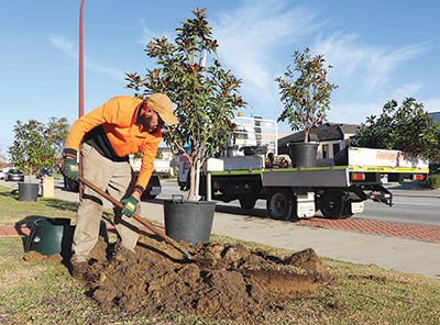
Planting and looking after trees in the City of Gosnells, Western Australia, has taken a technical turn, with the recent introduction of field data reporting and online mapping.
The City’s Environmental Services and Spatial Services teams have collaborated to implement a new way of collecting information on the planting, removal and maintenance of trees in parks and streetscapes.
Mayor, David Goode said staff and contractors had adapted a field data collection app to help the City better manage its ‘living assets’.
“Our new tree reporting system allows staff to upload images and data on site, which will link to the City’s mapping system to highlight tree plantings, tree inspections and surveys conducted in-house or by contractors.
“After a full year of data collection, we will have enough information to refine planting programs and improve accuracy of budgets for future years of tree planting and maintenance.
“We will know the number of trees in our parks and streetscapes, how many need pruning under power lines and where trees have been lost.
“This is really exciting for our community, as it will ultimately improve our tree canopy.
“Trees don’t just provide shade – they produce oxygen, absorb heat and pollutants, store carbon and help manage groundwater quality.
Leafy streets can even change the way we feel about where we live and increase property values.”
Aside from increasing its annual tree planting regime, City of Gosnells has also experienced a surge in the number of residents applying for free street trees.
In the past year, the City planted more than 2500 mature trees across its 11 suburbs.

