A new camera installed in the Fraser Coast Regional Council area is going to give residents fast alerts to flooded and closed roads.
Mayor Gerard O’Connell said that the status of the Hervey Bay – Maryborough Road, often closed during heavy rain, is very important to a lot of residents and the newly installed camera will greatly improve the alert process.
“Once the road is cut traffic between Hervey Bay and Maryborough is diverted along the Bruce Highway to Howard.”
When the Mary River is in flood, water can back up and cut the road at the bridge over Saltwater Creek, especially at high tide.
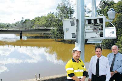
“To keep tabs on what is happening at the bridge Council has had a camera installed.
“Staff can log into the camera to see what is happening at any time so we can alert emergency service personnel and residents whether the bridge is open or closed.
“Eventually images from the camera will go straight on to our website so residents can log in and see what is happening.”
The solar-powered camera also collects river height information.
“The electronics can be easily modified so it could be set up as an alert monitor and automatically collect rainfall and other weather information as well.”
The camera forms a part of Council’s network of weather and river height monitors along the Mary River, Wide Bay Creek and Tinana Creek.
The $30,000 project is a joint project between Council and the State government.