Lake Macquarie City Council, New South Wales, is poised to deploy Google Street View-style technology to map and assess more than 1300km of roads across the local government area.
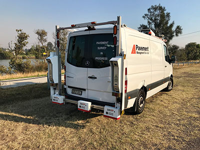
Known as an Automated Road Analyser (ARAN), the technology is mounted on the top of a van, with an array of cameras, GPS and lasers analysing the road surface and other road assets, metre-by-metre.
Council’s Manager Asset Management, Helen Plummer, said a condition survey of the City’s roads was required every five years to plan and prioritise improvements and upgrades.
“Maintaining more than 1300km of roads is a significant task with many competing priorities.
“This technology helps paint a clearer picture of what needs to be done and where.
“The analysis will provide a very accurate and detailed picture of everything from road roughness and pot-holing to the condition of kerb and gutter, median strips, signs and other road infrastructure.”
The ARAN vehicle will traverse every Council-owned bitumen sealed road in Lake Macquarie, covering about 50km a day, at a maximum speed of 40kmh.
“We’re expecting it will take six to seven weeks to cover the City’s entire local road network, weather permitting.”
Lake Macquarie Mayor, Kay Fraser, said that deploying this technology was another example of Council embracing innovation.
“Doing so not only improves work practices – it makes us a more efficient and effective organisation.”

