New technology is being used across a wide range of Local Government services and is playing an increasingly important part in redefining services offered by Kingborough Council, Tasmania.
Technology allows us to innovate in small and large ways and over time deliver significant improvements in efficiency and service.
For example, every day the need for 24 hour access to information grows. Customers want to be able to locate information when they need it, not just during business hours.
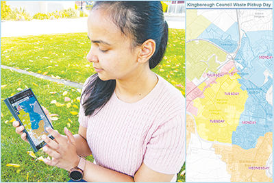
To improve the community’s access to information and provide a better service model, Council developed a digital interactive map for kerbside bin collections across Kingborough.
This is the first of several map themes to be developed as Council moves towards technological improvements for most of its service delivery.
Another example of technology in practice is offered by the exciting new opportunities in surveying and mapping provided by the use of drones.
Councils are increasingly utilising this new technology in a range of tasks including mapping, monitoring and emergency management.
The science behind drone use is photogrammetry, which deals with collecting physical information from photographs. Images collected by drones can be mosaiced together using computer programs to produce orthomosaic images and Digital Elevation Models (DEM). These products can be used for mapping, spatial analysis, and measurement.
Kingborough Council staff recently used drone photogrammetry to quantify a change in volume of a private property over nearly 20 years – supporting compliance efforts in relation to illegal deposition of landfill.
Photogrammetry will become a vital tool for Council as the technology advances. A relatively small annual investment in data along with skilled application by staff will support a myriad of uses including predesign work, visual presentation of works, hazard and condition analysis and more.

