Since 1999, Coffs Harbour City Council has played an active role in introducing Geographic Information System (GIS) technology into local schools.
Council’s GIS Administrator, Ron Graham, said all local high schools are currently using the technology. “The schools install the same GIS software package that Council uses to their computer networks or individual PCs,” he said. “Council then supplies each school with a range of local data, covering an area of approximately five kilometres around the school. This data includes air photos, cadastre, contours, zones, koala habitats and so forth. Each school uses the technology in various ways, but most look at environmental issues.”
Ron Graham said Coffs Harbour High School took out a national award following the use of GIS technology to map nearby Diggers Beach. With the help of Council’s Parks Department, the students identified and mapped existing vegetation and weeds and looked at how they were impacted by people not using walkways. They then developed a management plan to address these issues, which has since been adopted by Council.
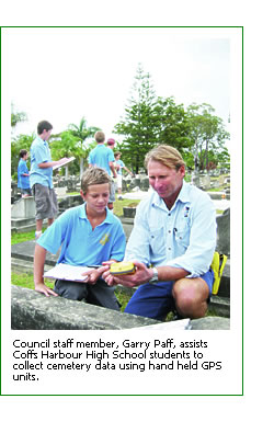
The same school is now conducting a history project using the technology. They are mapping Council’s historical cemetery to pinpoint who lies where, and to identify missing gravestones and any damage. Ron Graham said Council’s GIS staff have attended many of the schools to assist teachers and students in getting started.
“Initially we would go out on pupil free days and geography teachers would participate in a one day introductory course on how to use the software,” he said. “It is now more common for us to sit in computer lab sessions with students and show them directly how to use it.”
Council staff continue to provide assistance and advice to schools when required.
To assist with spreading the message on the capabilities of GIS and how it is used on a day to day basis, Council actively participates in the annual World GIS Day held each November. Demonstrations are held throughout the day with an open invitation extended to all schools as well as the general public.
“People can see how Council uses GIS technology and what it is all about,” Ron Graham said. “The technology that is available, and the extent to which Council is using it, often blows people away.” Council also hosts visits by school groups from around the region and students from high schools participating in work experience placement programs.
For further information contact Ron Graham on (02) 6648 4000.