Located within the central western slopes of New South Wales, Forbes Shire Council is using global positioning system (GPS) technology to reduce the survey and set out time required for road construction.
With a population of more than 10,000 people spread over 4,700 square kilometres, like many rural Councils Forbes struggles to attract skilled and professional staff. Council has only one skilled survey and design person. Therefore when searching for a solution to improve a core local road last year, Council looked to technology to close the manpower gap.
Council’s Works Manager, Danial Speer, said a project such as this would normally require hundreds of hours of this person’s time – time that is not available for just one project.
“Pavey’s Red Bend Road is a 3.4 kilometre link road between the highly productive agricultural areas in the southwestern parts of the Shire to the large grain collection silos in the main township and rural centre, Forbes,” he said. “It was a gravel road that was inadequate for large volume, heavy traffic usage that occurred during the grain harvest seasons. The dust generated also created a major safety hazard and upset neighbouring property owners. This naturally brought about many complaints from the rural sector, property owners and haulage contractors.”
Using the Federal Government’s Roads To Recovery funding, Council decided to construct and seal the road. Very early in the project development stage, it was identified that Council’s survey and design resources would be severely stretched. The use of contractors was considered but rejected, as the availability of the only local registered surveyor could not be guaranteed. Staging the works over a period of time was also looked at, but considered to be inefficient and would certainly mean that the November 2006 deadline – to ensure the road would be in use for the summer harvest – would not be met.
Council therefore decided to investigate the use of GPS technology.
Danial Speer said the key factors Council looked at were cost, training requirements, quality and, most importantly, how much surveying resources would be saved.
“Council’s construction plant was already fitted with Topcon laser systems, which are compatible with contractor, Laserquip’s, GPS equipment,” he said. “This meant the cost to use the GPS technology would be reduced. Laserquip could provide training and was prepared to spend time on the actual construction site with the plant operators to ensure that their skills in using the equipment were sufficient.
“As for quality assurance, the latest GPS technology can guarantee sub 20mm accuracy, which was more than sufficient for the project.
“To collect the initial survey data required for the design work, we used a Survey Rover, with GPS and satellite technology, and a field controller (handheld device) running Pocket 3D software. This unit was mounted on a motor vehicle and driven over the required survey area. It collected a data/survey point every two seconds, therefore allowing the survey to be done very efficiently. This method reduced the survey time to several hours, as opposed to days to complete.”
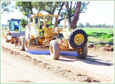
The road design was then completed using standard design software and transferred to the Rover GPS receiver attached to the construction plant, by way of a Compact Flash Card. This resulted in real time images of the location and design being featured on the screen display unit in the cabin of the grader. The technology has an automatic mode, which allows the software to operate the plants hydraulics and automatically respond to the design requirements. This ensures correct pavement depth, superelevation, crossfall and formation width and eliminates the need for Council’s surveyor to set out the works, including pegging the formation and the continuous requirement to undertake levels to ensure pavement thickness and project quality control.
For further information contact Danial Speer on (02) 6850 1300.

