The commissioning of South Australia’s $16.1 million Bruce Eastick North Para Flood Mitigation Dam in August represents a major achievement of collaboration and cooperation between Federal, State and six Local Governments.
In a flood, the dam will temporarily store stormwater. Outlet pipes in the dam wall allow stored water to be returned to the river at a reduced flow rate, which leads to the reduction in flooding downstream.
South Australian Minister for Local Government, Patrick Conlon, said the Gawler River has been subject to major flooding, on average, every ten years over the past 150 years.
“Major flooding occurred as a result of three floods in 1992, and most recently in November 2005 when Virginia and the surrounding areas were inundated, resulting in widespread damage to homes and properties,” he said.
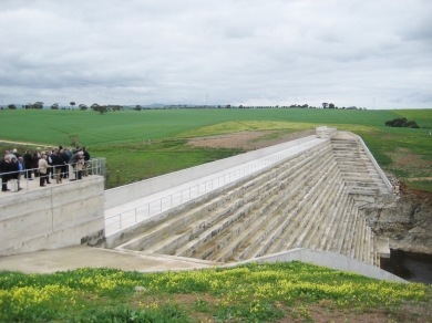
“The new dam has created a flood control feature 30 metres high, 26 metres deep at the base and 225 metres long. This will control floodwaters in the North Para River and further downstream in the Gawler River.
“SA Water will also continue to work with Local Government to increase the flood control capabilities at the South Para Reservoir by raising the height of the dam and modifying the spillway.”
Construction of the dam, which is named after former State and Federal politician Bruce Eastick, was funded as part of a major regional flood mitigation commitment by State and Federal Governments and the six councils – Adelaide Hills, Barossa, Gawler, Light, Mallala and Playford.
President of the Local Government Association of South Australia, Mayor Joy Baluch, said it is fantastic to see the three spheres of government working together in the best interests of local communities.
“This initiative represents a significant commitment by State, Federal and Local Government to upgrade and augment existing infrastructure to ensure that our communities are protected from peak environmental events,” she said. “There are still a number of properties in the Gawler Floodplain that would be at risk in the event of a one in one hundred year flood, and floodplain mapping has been undertaken to determine the extent of flood risk areas in about 220 square kilometres of the Lower Gawler Floodplain.
“There is still work to be done, but this is an excellent step in the right direction.”
The floodplain mapping undertaken to date has identified about 3,850 properties in four council areas that could still be at risk in a one in one hundred year flood.