In 2007 Liverpool Plains Shire Council decided to introduce a strategic approach to weed management with the introduction of weed mapping. Council’s weed inspector’s initially trialled an off the shelf software package however, the program failed miserably to deliver the desired outcomes.
Council management wanted a user friendly solution for the recording of weed data in the field during the property inspection process, in addition to benchmarking and performance monitoring functionality. With this in mind Council’s IT staff and Weed Inspectors set out to develop in-house a weed mapping program.
After many months of hard work the Tr@cer Weeds Mobile Mapping software was finally operational.
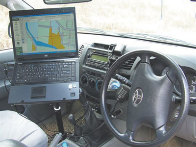
The program integrates with Council’s property data and Google Earth, allowing inspectors to pinpoint and map weed infestations. Tr@ceR Mobile Mapping combines mobile GPS satellite navigation with easy field data input via ‘Smart Forms’. GPS mapping allows inspectors to determine the property’s owner details, address and global position.
The software captures data such as weed type, infestation size and geographic infestation trends, enabling inspectors to recognise areas having a potential risk to the environment, and identify where containment and remediation action is required.
Tr@ceR Weeds also generates reports and inspectors can print these out while in the field and hand them to the landholder. This functionality saves time and money when compared to the old manual system where the processing of inspection reports was a duplication of the work conducted in the field.
“Previously, staff could spend up to ten hours per week entering data, filing reports and maps and retrieving information for the inspection program,” said Councils IT Manager Mark Daly.
In 2009 Liverpool Plains Shire Council won the prestigious National Award for Local Government in the Innovation in Natural Resource Management category for this mapping program.
Designed by weeds officers for weeds officers
Noxious Weeds Officer at Moree Plains Shire Council Ian Schwartz has recently swapped from another mapping product to Tr@ceR Weeds Mobile Mapping.
“Tr@ceR is simpler and easier to use because it has been designed by weeds officers for weeds officers,” Ian Schwartz said. “I would describe the previous system as very complex, whereas what we actually need in the field is the workhorse “Tr@ceR” which is easy to use.
“We are not IT experts, what we need is something that is easy to use, and if there are any glitches that these are sorted out quickly. The Tr@ceR Weeds backup service and advice has been excellent.”
He said that the Tr@ceR Weeds program can be easily altered to suit particular requirements and the reporting systems can be slotted into exactly what is needed.
“Another good thing is that it is linked to Google Earth,” he said. “So long as you have phone coverage, you can readily locate property boundaries and any other key geographical features you are looking for.”
Chief Weeds Officer at Inverell Shire Council, Les Tanner has been using Tr@ceR Weeds for six months.Similarly he has used other weed mapping programs and finds that Tr@ceR delivers exactly what is promised.
“It may not have all the bells and whistles of other programs but it is down to earth and user friendly. It is easy to change the pull down menus to suit our particular requirements,” he said. “This can be done in house but if we have required technical support, it has also been very good.”
Les Tanner said it is the reporting capabilities of Tr@ceR that really saves time.
“When we are reporting up the chain, Tr@ceR enables us to cover the full range of required variables such as categories, high risk areas, number of inspections, hectares and so forth,” he said.

|
Regional approach to weeds management
With some of its member councils (Local Control Authorities) using Tr@ceR Weeds to monitor and map weed infestations, the Border Rivers Gwydir Catchment Management Authority has recently funded the purchase of this solution to cover its remaining councils.
“With a number of our councils already using Tr@ceR and very happy with it, providing funding to ensure all our councils have it, provides a consistent approach to mapping weeds across the catchment,” said Jonathan Lawson, Invasive Species Catchment Officer with the Border Rivers Gwydir Catchment Management Authority.
One of 13 Catchment Management Authorities (CMAs) in New South Wales, Border Rivers Gwydir covers 50,000 square kilometres and is home to a complex diversity of plants, birds, animals, soils, land uses and communities. With over 1600 partnerships with community groups, schools, government bodies, industry groups and landholders, it currently has some 350,000 hectares under management control for invasive species and groundcovers. This catchment’s main centres include Moree, Tenterfield, Glen Innes and Inverell as well as numerous other smaller townships.
“Tr@ceR Weeds provides our property inspectors with real time mapping, as well as drop down menus to log the extent of infestations and the direction they are moving,” Jonathan Lawson said. “Providing consistency in our data collection and mapping makes our decisions regarding where containment lines should go and then monitoring the success of this action much easier. There is nothing else like it that I know of.”
He said that this mapping will enable the CMA to start modelling and link this with climate change data to predict how weed infestations will move.
“The ability to draw down data to actual property locations is absolutely vital in our work to eradicate invasive species, and Tr@ceR Weeds gives us this,” he said. “It is also ideal for monitoring high risk pathways such as rivers and road reserves. The Tr@ceR program can also be modified for mapping other environmental threats to the Catchment such as pinpointing the location and habitats of feral animals such as rabbits, pigs and foxes.”
For further information on Tr@cer Mobile Mapping contact Mike Urquhart or Mark Daly on (02) 6746 1755.